The Unique Maps Co.
Old Map of Westphalia by Visscher, 1690: Hamburg, Bremen, Hanover, Cologne, Dortmund
Old Map of Westphalia by Visscher, 1690: Hamburg, Bremen, Hanover, Cologne, Dortmund
Couldn't load pickup availability
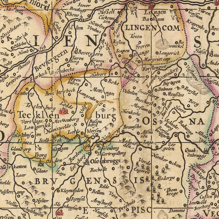
Dive into the rich history of Germany with this meticulously detailed map of Westphalia, crafted by the renowned cartographer Nicolaes Visscher II in 1690. This piece offers a captivating view of the political landscape of the time, revealing the intricate divisions within the Circulus Westphalici, or the Westphalian Circle. The full name of the map, 'Totius Circuli Westphalici: accurata descriptio Pr.', translates to 'An accurate description of the entire Westphalian Circle', indicating the comprehensive nature of this historic artifact.
The map prominently features five major cities: Hamburg, Bremen, Hanover, Cologne, and Dortmund. Each city is marked with precision, offering a unique glimpse into their significance during the late 17th century. Hamburg, known for its vital port, Bremen with its rich maritime history, Hanover, the erstwhile seat of royalty, Cologne, the cultural hub, and Dortmund, the imperial city, all find their place in this map.
Beyond the cities, the map also provides a broader view of the Westphalian Circle, a significant region within the Holy Roman Empire. The Westphalian Circle comprised various territories, each with its unique political and historical context. This map, therefore, serves as a window into the past, revealing the intricate dynamics of this region during a pivotal period in European history.
The map's creator, Nicolaes Visscher II, was part of the illustrious Visscher family of cartographers, artists, and publishers. Their works, renowned for their accuracy and artistic merit, were significant contributions to the Dutch Golden Age of cartography. This map, with its meticulous detail and historic value, is a testament to the Visscher legacy.
Some of the significant locations shown on this map:
Westphalia:
- Dortmund: Known as Tremonia in Latin, it was an important imperial city in the Holy Roman Empire.
- Münster: Historically known as Monasterium, it was the location of the signing of the Peace of Westphalia in 1648.
- Bielefeld: Founded as a city in 1214, it was a vital part of the linen trade.
- Gelsenkirchen: Known for its coal mines and ironworks during the industrial revolution.
- Bochum: Historically known for coal mining and steel production.
- Duisburg: Known as Divisia in Latin, it was a significant medieval trade center.
- Essen: Known for its historic Abbey, which was a center of power in the early Middle Ages.
- Osnabrück: Known as the 'City of Peace' for its role in the Peace of Westphalia.
- Paderborn: Known for its cathedral and university, it was a center of learning in the Middle Ages.
- Hamm: Founded in 1226, it was a member of the Hanseatic League.
- Herford: Known for its textiles and metal goods during the Middle Ages.
- Minden: Known for its cathedral and as a trading town of the Hanseatic League.
- Detmold: Known for its Renaissance castle.
- Lippstadt: Known as the 'Venice of Westphalia' due to its canals and streams.
- Gütersloh: Known for its historic town hall and market square.
Lower Saxony:
- Hanover: Known as 'Hannover' in German, it was the seat of the Electorate of Brunswick-Lüneburg.
Notable Natural Phenomena:
- The Rhine River: One of the major European rivers, which has its source in Switzerland.
- The Weser River: An important river in northern Germany, known for its scenic beauty.
- The Teutoburg Forest: Known for the Battle of the Teutoburg Forest in 9 AD.
- The Harz Mountains: The highest mountain range in northern Germany.
- The Ems River: Known for its meandering course through Lower Saxony and North Rhine-Westphalia.
Notable Historical Events (1600-1690):
- The Thirty Years' War (1618-1648): A devastating conflict that significantly impacted the region.
- The Peace of Westphalia (1648): The series of peace treaties that ended the Thirty Years' War.
- The Franco-Dutch War (1672-1678): A conflict that involved several German states, including those in the Westphalian Circle.
Please double check the images to make sure that a specific town or place is shown on this map. You can also get in touch and ask us to check the map for you.
This map looks great at all sizes: 12x16in (30.5x41cm), 16x20in (40.5x51cm), 18x24in (45.5x61cm), 24x30in (61x76cm), 32x40in (81.5x102cm), 40x50in (102x127cm), 48x60in (122x153cm) and 56x70in (142x178cm), but it looks even better when printed large.
I can create beautiful, large prints of this map up to 90in (229cm). Please get in touch if you're looking for larger, customised or different framing options.
The model in the listing images is holding the 16x20in (40.5x51cm) version of this map.
The fifth listing image shows an example of my map personalisation service.
If you’re looking for something slightly different, check out my collection of the best old maps of Europe and European cities to see if something else catches your eye.
Please contact me to check if a certain location, landmark or feature is shown on this map.
This would make a wonderful birthday, Christmas, Father's Day, work leaving, anniversary or housewarming gift for someone from the areas covered by this map.
This map is available as a giclée print on acid free archival matte paper, or you can buy it framed. The frame is a nice, simple black frame that suits most aesthetics. Please get in touch if you'd like a different frame colour or material. My frames are glazed with super-clear museum-grade acrylic (perspex/acrylite), which is significantly less reflective than glass, safer, and will always arrive in perfect condition.
Share