The Unique Maps Co.
Old Map of Southern Africa, 1967: Congo, Zambia, South Africa, Madagascar, Lake Victoria
Old Map of Southern Africa, 1967: Congo, Zambia, South Africa, Madagascar, Lake Victoria
Couldn't load pickup availability
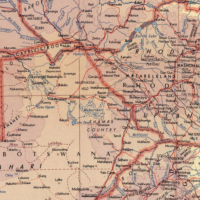
The 'Africa - South' map, published in 1967 by the esteemed Polish Army Topography Service, is a testament to the meticulousness of mid-20th-century cartography. This map is not merely a geographical representation but a detailed political and physical map, offering a fascinating glimpse into the geopolitical landscape of Southern Africa during a period of significant historical transition. The map encompasses all African countries from Congo down to South Africa, making it an intriguing piece for those interested in the region's historical and political nuances.
This map is further distinguished by its insets of the Sao Tome and Principe Islands, the Mascarene Islands, and Madagascar. These detailed insets offer a unique perspective on these often overlooked yet historically significant islands. Sao Tome and Principe, for instance, were critical waypoints in the age of exploration, while the Mascarene Islands and Madagascar have unique biodiversity that has fascinated scientists for centuries. These insets serve as a testament to the mapmaker's attention to detail and commitment to comprehensive representation.
The 'Africa - South' map is a World Map, a format that allows for a broad overview of the region while maintaining a high level of detail. This style of map is particularly interesting because it offers a balance between the macro and micro perspectives, enabling the viewer to appreciate the region's broader context while also delving into its specific features. This map, with its blend of political and physical details, is an excellent example of this approach, offering a multifaceted view of Southern Africa and its surrounding islands.
Lastly, the artistic style of the mapmaker is worth noting. The Polish Army Topography Service was renowned for its precision and accuracy, and this map is no exception. The careful delineation of political boundaries, the detailed rendering of physical features, and the thoughtful inclusion of insets all contribute to a map that is as aesthetically pleasing as it is informative. The projection of the map, a critical aspect of any cartographic work, is executed with precision, ensuring that the map is as accurate as possible. This commitment to accuracy and aesthetics makes the 'Africa - South' map a valuable addition to any collection.
- Cartographic Style and Projection
- Detailed political and physical map, offering a comprehensive view of the region
- World Map format, allowing for a broad overview while maintaining a high level of detail
- Precise delineation of political boundaries
- Detailed rendering of physical features
- Thoughtful inclusion of insets of significant islands
-
Accurate projection ensuring a faithful representation of the geographical area
-
Interesting Facts about the Cartographer
- The map was created by the Polish Army Topography Service, renowned for their meticulousness and accuracy
- The Polish Army Topography Service was known for their detailed political and physical maps
-
The cartographer's commitment to comprehensive representation is evident in the inclusion of insets of often overlooked islands
-
Interesting Historical or Physical Features Shown by This Map
- The map covers all African countries from Congo down to South Africa
- The map provides a glimpse into the geopolitical landscape of Southern Africa during a period of significant historical transition
- The map includes insets of the Sao Tome and Principe Islands, the Mascarene Islands, and Madagascar
- Sao Tome and Principe were critical waypoints in the age of exploration
- The Mascarene Islands and Madagascar are known for their unique biodiversity
- The map offers a balance between the macro and micro perspectives, providing a broad context and specific features of the region
- The map is as aesthetically pleasing as it is informative, making it a valuable addition to any collection
Please double check the images to make sure that a specific town or place is shown on this map. You can also get in touch and ask us to check the map for you.
This map looks great at every size, but I always recommend going for a larger size if you have space. That way you can easily make out all of the details.
This map looks amazing at sizes all the way up to 50in (125cm). If you are looking for a larger map, please get in touch.
Please note: the labels on this map are hard to read if you order a map that is 16in (40cm) or smaller. The map is still very attractive, but if you would like to read the map easily, please buy a larger size.
The model in the listing images is holding the 18x24in (45x60cm) version of this map.
The fifth listing image shows an example of my map personalisation service.
If you’re looking for something slightly different, check out my collection of the best old maps to see if something else catches your eye.
Please contact me to check if a certain location, landmark or feature is shown on this map.
This would make a wonderful birthday, Christmas, Father's Day, work leaving, anniversary or housewarming gift for someone from the areas covered by this map.
This map is available as a giclée print on acid free archival matte paper, or you can buy it framed. The frame is a nice, simple black frame that suits most aesthetics. Please get in touch if you'd like a different frame colour or material. My frames are glazed with super-clear museum-grade acrylic (perspex/acrylite), which is significantly less reflective than glass, safer, and will always arrive in perfect condition.
Share