The Unique Maps Co.
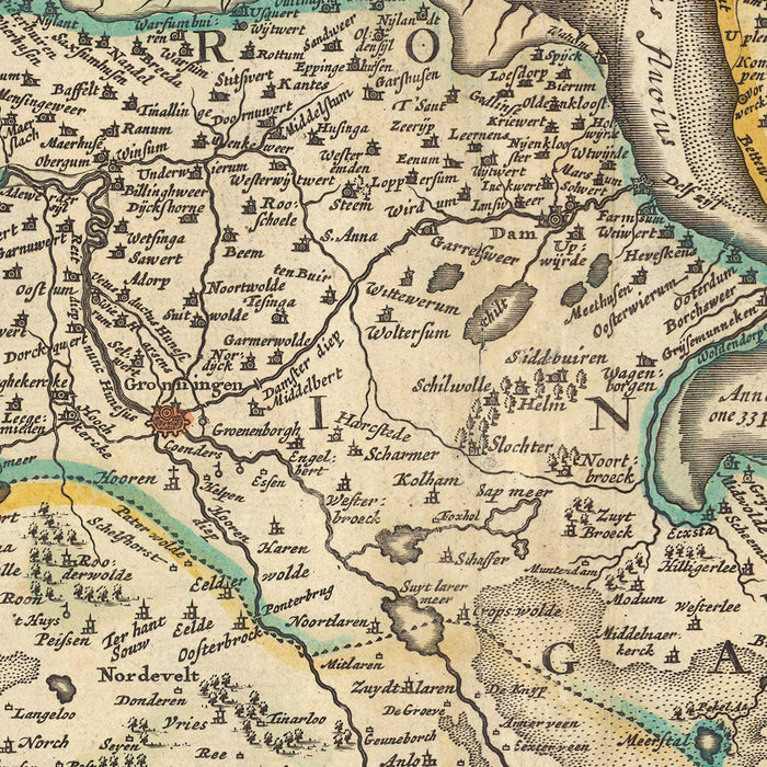
Old Map of Friesland and Groningen by Visscher, 1690: Oldenburg, Zwolle, Leeuwarden, Emmen, Kampen
Old Map of Friesland and Groningen by Visscher, 1690: Oldenburg, Zwolle, Leeuwarden, Emmen, Kampen
Couldn't load pickup availability
Step back in time with this meticulously detailed map of Friesland and Groningen, created by the esteemed mapmaker Nicolaes Visscher II in 1690. Known for his precision and attention to detail, Visscher II brings to life the rich topography and intricate political boundaries of the region, during a time when the Dutch Republic was a major global power.
The full name of the map, 'Tabula Frisiae, Groningae, et Territorii Emdensis nec non circumjacentium Regionum, puta Transisalaniae, Benthemiae, Westphalae et Oldenburgi', translates to 'Map of Friesland, Groningen, and the Territory of Emden, as well as the surrounding regions, namely Transisalania, Bentheim, Westphalia, and Oldenburg'. This expansive coverage provides a comprehensive view of the northern Netherlands and northwestern Germany during the late 17th century.
The map features several significant cities and landmarks. Oldenburg, a key city in Lower Saxony, Germany, is depicted with its historical boundaries. Zwolle, the capital city of the province of Overijssel, Netherlands, is also prominently featured. The cities of Leeuwarden, the cultural hub of Friesland; Emmen, a large town in Drenthe; and Kampen, a city of the province of Overijssel, are also detailed on the map.
The historical and geographical significance of this map is undeniable. It provides a unique perspective on the region during a time of significant political and cultural shifts. This map is not just a piece of cartography; it's a window into the past, offering insights into the geographical knowledge and political landscape of the Dutch Golden Age. A true treasure for any collector or history enthusiast.
Some of the significant locations shown on this map:
Friesland
- Leeuwarden: The cultural hub of Friesland, historically known as 'Liwwadden'.
- Sneek: Known for its historic city centre, which has over 100 listed buildings.
- Franeker: Home to the oldest operational planetarium in the world.
- Harlingen: A significant seaport town in the Dutch Golden Age.
- Heerenveen: Known for its long-standing tradition in speed skating.
- Drachten: A rapidly growing town in the 17th century.
- Dokkum: Known for its fortified town center.
- IJlst: Known for its scenic canals and historic buildings.
- Bolsward: A trading city, known for its stunning architecture.
- Workum: Known for its ceramic industry.
Groningen
- Groningen: The largest city in the north of the Netherlands.
- Veendam: Known as the 'Parkstad' (Park City) of Groningen.
- Winschoten: Known for its three historic windmills.
- Stadskanaal: Developed around the Stadskanaal (City Canal).
- Delfzijl: An important seaport in the province of Groningen.
- Hoogezand-Sappemeer: Known for its peat colonies.
- Leek: Known for the 'borg Nienoord', a manor with beautiful gardens.
- Zuidhorn: Known for the historic 'Van Starkenborgh' canal.
- Haren: Known for its beautiful villas and the Hortus Haren, a botanical garden.
- Appingedam: Known for its hanging kitchens above the Damsterdiep.
Notable Natural Phenomena
- Ems River: A major river in northwestern Germany.
- Wadden Sea: A UNESCO World Heritage Site.
- Dollart Bay: A bay in the Wadden Sea.
- Ijsselmeer: The largest lake in Western Europe.
- Teutoburg Forest: A historic forest in Westphalia.
Notable Historical Events
- The Battle of Nieuwpoort (1600): A significant battle in the Dutch War of Independence.
- The Synod of Dort (1618-1619): A significant religious assembly during the Dutch Golden Age.
- The Treaty of Münster (1648): The treaty that ended the Eighty Years' War and recognized the Dutch Republic.
Please double check the images to make sure that a specific town or place is shown on this map. You can also get in touch and ask us to check the map for you.
This map looks great at all sizes: 12x16in (30.5x41cm), 16x20in (40.5x51cm), 18x24in (45.5x61cm), 24x30in (61x76cm), 32x40in (81.5x102cm), 40x50in (102x127cm), 48x60in (122x153cm) and 56x70in (142x178cm), but it looks even better when printed large.
I can create beautiful, large prints of this map up to 90in (229cm). Please get in touch if you're looking for larger, customised or different framing options.
The model in the listing images is holding the 16x20in (40.5x51cm) version of this map.
The fifth listing image shows an example of my map personalisation service.
If you’re looking for something slightly different, check out my collection of the best old maps of Europe and European cities to see if something else catches your eye.
Please contact me to check if a certain location, landmark or feature is shown on this map.
This would make a wonderful birthday, Christmas, Father's Day, work leaving, anniversary or housewarming gift for someone from the areas covered by this map.
This map is available as a giclée print on acid free archival matte paper, or you can buy it framed. The frame is a nice, simple black frame that suits most aesthetics. Please get in touch if you'd like a different frame colour or material. My frames are glazed with super-clear museum-grade acrylic (perspex/acrylite), which is significantly less reflective than glass, safer, and will always arrive in perfect condition.
Share